Tuesday, May 29, 2007

May 24 - 30: Panquitch, UT (Bryce National Park)

We did three days of touring in this area.

First we drove 40 miles to the Fremont Indian State park. It is a remarkable area that has preserved the petroglyphs of the Fremont Indians. They lived in the area before the 13oo's and noone seems to know what happened to them after they left. But they left behind multitudes of rock art.


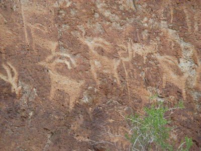
It seemed as though everywhere we walked there were drawings on the rocks.


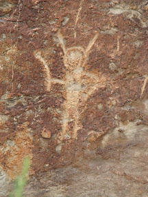
Many of the drawings have meanings that to this day, noone has been able to explain. And many others are clearly people, sheep, rams with huge horns, rivers, concentric circles and one very tall (6') drawing of a person.

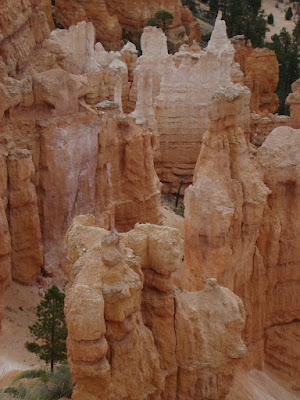
The next day we drove to Bryce Canyon.

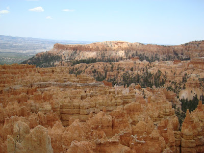
Now that is an absolutely magnificient area. The hoodoos are inexplicably awesome. And the color in the rocks and peaks are this very vivid red with white limestone leaching through.


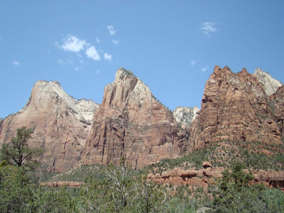
We learned the relationship between the Grand Canyon, Zion, and Bryce. Geologically, the Grand Canyone is at the bottom, the top of the Grand Canyon is Zion, and the top of Zion is Bryce.

And yesterday, we drove to Cedar Breaks National Monument. It was a beautiful drive up to 10,000' in the mountains with landscape of cedars, big pine, spruce, and other rocky mountain trees. And then we came to a vast area with red rocks much the same color and configuration of Bryce. So we experienced views from mountain pines and snow to vast area of red rock and then the landscape changed to huge pilings of volcanic rock. At first, it looked like someone had dug up the land and made huge hills of rocks. And then we learned that this is the remnants of volcanic eruptions. These large volcanic piles were taller than many of the pine trees and covered many miles of expanse.

Today is rest day. Clean the motorhome, update the blog, read, rest, prepare the motorhome for travel for tomorrow.

Next destination: Mt. Pleasant, Utah. Two weeks of completing projects and reading and who knows. We will check out the area. All we know is that it is 8000' in the mountains and a beautiful area.

Love to all of you,
Linda and Barb

Thursday, May 24, 2007

May 18-24: Zion National Park

May 18: We left Vegas and traveled to Zion. As you can see from the previous blog, we were assigned what we consider an absolutely perfect campsite. We are right at the base of the Watchman Peak

May 19: We rode the shuttle from the Visitor Center to the end of the Zion Canyon. During the peak season, you cannot drive your car through the Canyon. The shuttle has about 8 stops in the Canyon so you can get off and see sights around that stop. A shuttle arrives at each stop every 6-8 minutes, so it is quite convenient and perhaps, even easier that driving our own car, finding a parking place, getting in and out.


For our first day, we stopped at the Patriarchs Peak so I could get a good picture while the sun was in the right spot. Then we traveled to the end of the canyon to the Riverside trail. It is about a mile and ends at the narrows. NO, we did not walk the narrows. Walking on the rocks of a river back into a narrow canyon did not sound good to us. Plus everyone who came out had water up to their hips, which would mean water up to our waist. NOT FOR US !


Actually by the time I stopped every 4 feet to take 6 pictures, it took us 2 hours to walk the mile to the narrows. Walking out took 20 minutes; Barb would not let me stop for pictures again!

May 20: We took a drive to the Coral Pink Sand Dunes. To get to the sand dunes we had to drive over highway 9, which took us to the Checkerboard Peak and through the tunnel. The sand dunes actually were a beautiful coral color and great to see.

May 21: We drove to the northern section of Zion, called Kolob Canyon. Drove through the canyon, hiked a mile up a bluff to view the entire area,

and then we rested and had a picnic.

May 22: We started the morning with a Ranger sponsored shuttle. It was 2 hours with Ranger selected stops to teach us about the geology of the area.

May 23: We hiked about a mile to the Emerald Pool to see a waterfall. Nice hike. Waterfall was more a trickle due to poor snow/rain conditions.

May 24: We left Zion to head to Panquitch, Ut in the Bryce National park area.

Love to all of you,
Linda and Barb

Friday, May 18, 2007

Zion National Park

WOW !!! This place is beautiful !!

We pulled into the campground, not knowing what our site would look like and found we had been assigned a perfect spot. We are located at the base of the Watchman Peak and have other peaks surrouding us on all sides. The first day we just sat outside and stared. As the evening approached, we made a campfire. Then the sunset came and the colors on the peaks just changed each moment. A glorious place to be.

Saturday we plan to take the shuttle into the Zion Valley. Probably we will take some short hikes. We would like to hike the 2 miles along the Riverside Hike back to what is called the Narrows. Will let you know how far we get.

Also, I have my new camera now. It is a Sony cybershot DSC-H9. It is the closest digital camera to an SLR without being one. So I will testing it out while we hike. So that means an hour and a half hike will probably take us four hours.
Love to all of you,
Linda and Barb

Wednesday, May 16, 2007

Back to Vegas Again

We returned to Vegas after Lake Havasu and had more time to spend with the kids.
The first weekend we returned, Robyn and Scott had a conference for the entire weekend. Zack and Ashley stayed with us in the motorhome for the first time. They were really excited by that. We were at the Oasis RV Park that had a swimming pool with a sand "beach" next to it. Since the temperature was in the lower 70's and too cold for swimming, the kids spend several hours just playing in the sand.

We even did some siteseeing with them and took a drive to the Valley of Fire. That is an absolutely beautiful area.


When we leave Vegas, we will head for Zion National park.

Love to all of you,

Linda and Barb

Posted by Picasa